

You need to agree to share your contact information to access this dataset
This repository is publicly accessible, but you have to accept the conditions to access its files and content. Once your access request is approved, you will be provided with the credentials required to download the full dataset.
Log in or Sign Up to review the conditions and access this dataset content.
NATIX Multi-Camera Driving Dataset
Summary
The NATIX Multi-Camera Driving Dataset is a real-world driving dataset. Unlike fleet-collected datasets that rely on trained safety drivers operating standardized vehicles, NATIX sources its data from a decentralized vehicle network consisting of everyday, non-expert drivers, resulting in more natural driving behavior and a broader distribution across real-world scenarios.
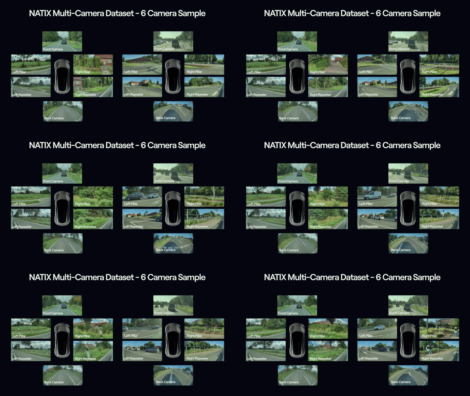
NATIX plans to release 2,000+ hours of data as part of this initiative. This first public release contains 100 hours of multi-camera driving footage with GPS/GNSS, camera calibration, and trip-level metadata collected across multiple countries, road types, weather conditions, and driving environments. The dataset is designed to support research in Physical AI, autonomous driving, world models, robotics, mapping, and end-to-end driving systems.
Note that the GPS data provided in this dataset is collected via a consumer-grade sensor installed on our data collection device. NATIX is also collecting telemetry data, including but not limited to automotive-grade GPS, pedal position, wheel angle, and more. We will publish a telemetry-included dataset soon.
This dataset supports research on:
- End-to-end driving models
- Vision-Language-Action (VLA) models
- World foundation models
- Multi-camera perception
- Mapping
- Scenario mining via VLM
- Driving scene understanding and simulation in graphics-based simulators
We strongly support open research and initiatives. If you are a researcher, academic institution, or open-source project interested in accessing larger portions of the dataset than publicly available, we'd love to hear from you, and we're happy to support and help accelerate research in Physical AI and autonomous driving. For more information, please contact us at dataset@natix.io.
If you are using NATIX data for any applications, please contact us to feature your project here.
Each trip contains:
- Footage, recorded by Tesla dashcams and segmented into approximately 1-minute
.mp4clips - GPS metadata, delivered per
.mp4clip as CSV - Trip-level metadata, including Trip Insight and Fixed Metadata
Important Notes
- This dataset is anonymized: faces and license plates blurred; known sensitive/military areas removed. However, real-world crowd-sourced data can contain unexpected cases. In case anything sensitive, personal, restricted, incomplete, or inconsistent appears in the dataset, the consumer of this dataset is responsible for immediately notifying NATIX at dataset@natix.io and deleting the affected data from their local copy.
- Metadata fields are best-effort estimates, especially values derived from third-party APIs or baseline calculations, such as weather, temperature, estimated distance, and estimated average speed. Treat these fields as guidance, not ground truth.
Dataset Statistics (Full dataset)
| Metric | Value |
|---|---|
| Dataset name | NATIX Multi-Camera Driving Dataset |
| Release identifier | natix-multi-camera-driving-dataset |
| Trips | 2,736 |
| Countries | 2: Switzerland, United States |
| Total duration | 100.0 hours / 6,001 minutes |
| MP4 clips | 30,902 |
| Total files | 114,614 |
| Total size | 1,283.58 GB |
| 4-camera footage | 2,551 minutes |
| 6-camera footage | 3,450 minutes |
| Switzerland | 30 minutes |
| US / California | 4,209 minutes |
| US / Colorado | 18 minutes |
| US / Florida | 1,278 minutes |
| US / Georgia | 66 minutes |
Access and Download the Full Dataset
The Hugging Face repository is only a 20-minute sample (dataset-sample/ folder), which contains 6 complete trips selected from Switzerland and the United States. The full dataset is hosted externally on Cloudflare R2 (larger than 1 TB)
This dataset is gated. To download the dataset, please request access on this page. Once your access request is approved, you will be provided with the ACCESS_KEY and SECRET_KEY credentials required for the download script below.
Note: you need 1,283.58 GB of free storage
Install dependencies:
pip install boto3
Download the full dataset:
import boto3
from pathlib import Path

ENDPOINT_URL = "https://e613d208b194c3a6749f5cc0a1ca5510.eu.r2.cloudflarestorage.com"
BUCKET_NAME  = "natix-prod-100h-open-source"
ACCESS_KEY   = "PROVIDED_ACCESS_KEY"    # provided after access request is approved
SECRET_KEY   = "PROVIDED_SECRET_KEY"    # provided after access request is approved
DEST_DIR     = Path("./dataset")

s3 = boto3.client(
    "s3",
    endpoint_url=ENDPOINT_URL,
    aws_access_key_id=ACCESS_KEY,
    aws_secret_access_key=SECRET_KEY,
)

paginator = s3.get_paginator("list_objects_v2")
for page in paginator.paginate(Bucket=BUCKET_NAME):
    for obj in page.get("Contents", []):
        key       = obj["Key"]
        dest_path = DEST_DIR / key
        # Creating parent directories as needed
        dest_path.parent.mkdir(parents=True, exist_ok=True)
        print(f"Downloading: {key}")
        s3.download_file(BUCKET_NAME, key, str(dest_path))
Dataset Overview
Footage: recorded via vehicle surround-view camera system and segmented into approximately 1-minute
.mp4files.- 4-camera trips:
FRONT,REAR,LEFT,RIGHT. - 6-camera trips:
FRONT,REAR,LEFT_REPEATER,RIGHT_REPEATER, plus two pillar cameras:LEFT_PILLAR,RIGHT_PILLAR. - Camera FOV (Field of View): Front ~50°; Rear ~140°; Side ~90°; Side Pillar ~90°.
- Resolution depends on the vehicle type and camera. Observed examples include
- 1280 x 960 across all cameras in some 4-camera trips
- 1448 x 938 for the standard cameras in some 6-camera trips, and,
- in some 6-camera trips, a natively larger front camera, for example, 2896 x 1876.
- All faces and license plates are blurred. In addition, 14% of the bottom of all rear-camera footage is blurred/anonymized.
- 4-camera trips:
Time-series metadata
- GPS metadata, 1-10 Hz: Per-camera, frame-matched location and motion metadata.
Trip-level metadata
- Trip Insight: high-level aggregated metadata about the trip, including duration, estimated distance, estimated average speed, per-minute weather, road type, location context, and camera availability.
- Fixed Metadata: values that do not change during a trip, including vehicle/platform information, camera intrinsics, camera extrinsics, and sensor positions.
Artifacts included in this Dataset
| Component | Location | Availability |
|---|---|---|
Footage (.mp4, per camera) |
Camera folder | Included |
GPS metadata (.csv, per camera) |
Camera folder | Included |
trip_insight.json |
Trip root | Included |
fixed_metadata.json / .csv |
Trip root | Included |
Schema files (telemetry_data.proto, trip_metadata.proto) |
Trip root | Included |
mapping.txt |
Segment folder | Expected. Contact NATIX if missing or inconsistent. |
trip_manifest.jsonl |
/ |
Included. Trip-level manifest for all trips |
dataset-sample/ |
/ |
Included. 6 complete trips from Switzerland and the United States |
Dataset Folder Structure
📁 dataset/
├── 📁 Country/[State]/
│   └── 📁 <trip-id>/
│       ├── 📁 HH-MM-SS/
│       │   ├── 📁 FRONT_FOLDER/
│       │   │   ├── FRONT_<YYYY-MM-DD>_<HH-MM-SS>.mp4
│       │   │   ├── FRONT_<YYYY-MM-DD>_<HH-MM-SS>.csv
│       │   │   └── FRONT_<YYYY-MM-DD>_<HH-MM-SS>.mcap
│       │   ├── 📁 REAR_FOLDER/
│       │   │
│       │   │   # 4-camera trips additionally contain:
│       │   ├── 📁 LEFT_FOLDER/
│       │   ├── 📁 RIGHT_FOLDER/
│       │   │
│       │   │   # 6-camera trips additionally contain:
│       │   ├── 📁 LEFT_REPEATER_FOLDER/
│       │   ├── 📁 RIGHT_REPEATER_FOLDER/
│       │   ├── 📁 LEFT_PILLAR_FOLDER/
│       │   ├── 📁 RIGHT_PILLAR_FOLDER/
│       │   │
│       │   └── mapping.txt
│       │
│       ├── 📁 HH-MM-SS/
│       │   └── ...
│       │
│       ├── trip_insight.json
│       ├── fixed_metadata.json
│       ├── fixed_metadata.csv
│       ├── fixed_metadata.mcap
│       ├── telemetry_data.proto
│       └── trip_metadata.proto
Data Definitions
Trip Manifest
The manifest contains one JSON object per trip folder, not one JSON object per individual file. Each row describes a self-contained trip folder and includes the trip prefix, country or region, duration, camera configuration, file count, total size, counts for per-camera data files, and segment timestamps. The complete trip-level manifest is provided as: trip_manifest.jsonl
| Field | Description |
|---|---|
trip_id |
Trip folder identifier, including the continuous-piece suffix where applicable |
country |
Country of the trip |
state |
State or region when available, otherwise null |
prefix |
Relative path to the trip folder under the R2 dataset root |
duration_min |
Trip duration in minutes |
cam_count |
Number of cameras in the trip configuration |
cameras |
Camera folders present for the trip |
file_count |
Total number of files inside the trip folder |
size_bytes |
Total trip folder size in bytes |
formats |
Count of per-camera data files by extension, such as mp4 and csv |
timestamps |
Segment start-time folders included in the trip |
GPS Metadata
Each GPS Metadata file is located in its camera folder and is named like the corresponding .mp4 file, for example, FRONT_2025-11-12_21-07-33.csv. It contains frame-matched GPS position and motion metadata.
| Field | Description |
|---|---|
timestamp |
ISO-8601 timestamp with millisecond precision |
frame_number |
Frame index synced to the .mp4, starting at 1 |
GPS_latitude_deg, GPS_longitude_deg |
Latitude and longitude |
horizontal_accuracy_m |
Location uncertainty in meters |
speed_mps |
Estimated speed in meters per second, from the location data |
velocity_north_mps, velocity_east_mps |
Velocity components toward north and east in meters per second |
heading_deg |
Heading in degrees, clockwise, 0 = north, calculated from position updates |
heading_accuracy_deg |
Heading uncertainty in degrees |
image_direction |
Direction the camera faces in this frame, in degrees, clockwise, 0 = north; calculated from heading and camera mounting direction |
Notes 1- Missing values are encoded as the literal string
na. 2- Rows may skip frame numbers on any camera, including the front camera. When no GPS update is available for a footage frame, that frame may have no row. Do not assume one row per frame.
Fixed Trip Metadata
At the root of each trip folder, static information that does not change during the trip is provided in multiple equivalent formats: fixed_metadata.json and fixed_metadata.csv.
Top-level fields
| Field | Description |
|---|---|
version |
Schema version |
trip_identifier |
Trip UUID, without the _<n> piece suffix |
frame_width, frame_height, frame_mp |
Footage frame size in pixels and megapixels; see the note below |
vehicle_make, vehicle_model |
Vehicle make and model, for example, Tesla / model3 or modely |
platform_type_video |
Source platform of the footage, for example, Tesla |
reference_frame |
Reference frame of all extrinsics, for example, ground_nominal |
Front camera resolution note
frame_widthandframe_heightdescribe the trip standard cameras. In some 6-camera trips, the front camera is natively larger, for example, 2896 x 1876 instead of 1448 x 938. Its intrinsic parameters, such asfx,fy,cx, andcy, are already expressed at the native front-camera size. Use them as shipped together with the actual pixel size of the front footage. NATIX does not resize the footage.
device_extrinsics - one entry per device. Camera entries contain:
| Field | Description |
|---|---|
device_name |
e.g. camera_front, camera_rear; camera_left, camera_right in 4-camera trips; camera_left_repeater, camera_right_repeater, camera_left_pillar, camera_right_pillar in 6-camera trips |
fx, fy, cx, cy |
Camera intrinsics, estimated, in pixels |
k1, k2, k3, p1, p2 |
Radial and tangential distortion, estimated |
r11 ... r33 |
3 x 3 row-major rotation matrix: orientation of the camera relative to ground_nominal |
tx, ty, tz |
Translation of the device relative to ground_nominal, based on usual device locations |
field_of_view_hor_deg, field_of_view_ver_deg |
Horizontal and vertical field of view in degrees |
Trip Insight
At the root of each trip folder, trip_insight.json gives an overview of the whole trip. For split trips, it describes the standalone trip piece.
Trip-level fields
| Field | Description |
|---|---|
startEpochMs, endEpochMs |
Trip start and end time in Unix epoch milliseconds |
duration |
Trip duration in milliseconds |
estimatedDistance |
Estimated distance traveled in kilometers |
estimatedAverageSpeed |
Estimated average speed over the trip in km/h |
firstLocation |
Object with latitude and longitude of the trip first GPS position |
timezone |
IANA timezone string, for example, America/New_York |
minutes |
Array of per-minute objects, each keyed by YYYY-MM-DD_HH-MM |
Per-minute fields
| Field | Type | Description |
|---|---|---|
weather |
list | Observed weather conditions, for example, ["Clear"] |
temperature |
list | Temperature in C, for example, [7.4] |
timeOfDay |
list | Time-of-day category, for example, ["day"], ["dusk"] |
roadType |
list | OSM-based road type, for example, ["motorway"], ["residential"] |
country |
string | Country name |
region |
string | Region or state |
place |
string | City or town |
district |
string | Administrative district |
postcode |
string | Postal code |
locality |
string | Locality sub-area |
neighborhood |
string | Neighborhood name, may be empty |
address |
string | Street address or area name |
cameraCount |
number | Number of cameras present in this minute |
footageCount |
number | Number of cameras with available footage in this minute |
camera flags |
boolean | Whether footage exists per camera |
The camera-existence flags match the trip camera configuration:
- 4-camera trips:
frontCameraExists,rearCameraExists,leftCameraExists,rightCameraExists - 6-camera trips:
frontCameraExists,rearCameraExists,leftRepeaterCameraExists,rightRepeaterCameraExists,leftPillarCameraExists,rightPillarCameraExists
Special Considerations
General Footage and File Notes
- Footage may have different frame rates and durations, even within the same segment.
- Different durations, same frame rate: Front - 00:01:00.21 @ 36.02 fps; Rear - 00:01:00.00 @ 36.02 fps.
- Different durations, different frame rates: Front - 00:01:00.06 @ 36.03 fps; Rear - 00:01:00.36 @ 34.62 fps.
- Split trips use the
<trip-id>_<n>folder format. Each piece contains continuous minutes and has its own metadata. - If footage, metadata, or camera-folder contents appear missing or inconsistent, please contact NATIX so the dataset can be reviewed.
GPS Data Processing
- GPS rows can skip frame numbers on any camera, including the front camera. Do not assume one metadata row per frame.
- GPS data is first aligned with the front footage. Because camera durations and frame rates can differ, other cameras may have different row counts or different matched metadata per frame.
- Time sync error between vehicle camera/video data and GPS data is expected to be 0-1 seconds, and in extreme cases up to 3 seconds.
- When GPS updates arrive too quickly, such as in two consecutive frames,
heading_degandspeed_mpsmay be 0 because they are calculated from position updates.
Trip Insight Estimate Notes
Some Trip Insight values, such as estimatedDistance, estimatedAverageSpeed, weather, and temperature, are best-effort estimates derived from third-party APIs or baseline calculations. Treat them as guidance, not ground truth.
License and Usage Terms
This dataset is released by NATIX under the NATIX Data RAIL-NC License, a responsible-AI data license adapted from the BigScience Open RAIL-M License.
Under this License, the dataset may be used for non-commercial purposes only, subject to the use-based restrictions set out in the License, and may not be redistributed or made available to third parties. The License is granted for a limited term. Commercial use is NOT permitted without separate written permission from NATIX. For the full license text, see LICENSE.md.
Disclaimer This dataset is provided "as is" and "as available", without warranties of any kind, whether express or implied, including but not limited to warranties of merchantability, fitness for a particular purpose, accuracy, or non-infringement. While faces and license plates have been blurred and known sensitive areas removed, NATIX does not warrant that anonymization is complete or that all sensitive areas have been excluded. NATIX makes no guarantees regarding the completeness, reliability, or correctness of the data and provides no support, maintenance, or updates. Use of this dataset is entirely at the consumer's own risk, and NATIX shall not be liable for any damages or losses arising from its use.
Attribution and Citation
There is no separate paper required for citation. If you use this dataset, please credit NATIX and link to the dataset page.
Recommended attribution:
NATIX Multi-Camera Driving Dataset. 2026. Available on Hugging Face Hub. NATIX Website: https://www.natix.network/
BibTeX:
@misc{natix2026_multi_camera_driving_dataset,
  title        = {NATIX Multi-Camera Driving Dataset},
  author       = {{NATIX}},
  year         = {2026},
  publisher    = {NATIX},
  howpublished = {Hugging Face Hub},
  url          = {https://huggingface.co/datasets/natix-network-org/natix-multi-camera-driving-dataset},
  note         = {Multi-camera driving dataset with telemetry metadata. Website: https://www.natix.network/}
}
Contact Us
We check every dataset before release, but real-world crowd-sourced data can contain surprises. If anything in the dataset looks sensitive, incomplete, inconsistent, or unexpected, please contact NATIX so it can be reviewed.
NATIX has built a unique, large-scale multi-camera driving dataset crowd-sourced from vehicles' cameras globally. This data is currently being used by various physical AI players supporting world foundational models, end-to-end (E2E) driving models, and simulation-based workflows for training, testing, and validation. For more info, you can contact NATIX directly at dataset@natix.io.
- Downloads last month
- 4